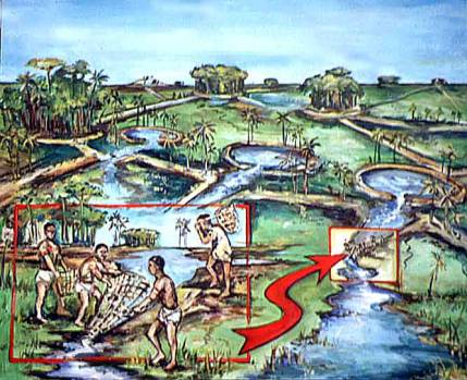
Fig. 3: Pre-Columbian fish weirs and
ponds in the savannas of Baures, Bolivia
(painting by Dan Brinkmeier, Field
Museum of Natural History
Pre-Columbian
Fish Farming in the Amazon
Clark L.
Erickson, PhD
Article published in Expedition
43(3):7-8 (2001).
Popular images associated with the Amazon today
include the towering continuous green forest canopy, Day-Glo poison dart frogs,
and natives' faces painted red. These potent images have been used to raise
funds for conservation, educate the public in “green” politics, and promote
ecotourism. Two themes have long dominated the popular and scientific
literature on the Amazon: 1) the Myth of the Pristine Environment and 2) the
Myth of the Noble Savage. The Myth of the Pristine Environment is the belief
that the landscapes of the Americas were largely undisturbed Nature until the
arrival of Europeans, who have destroyed the environment with their
agriculture, mining, urbanism, and industry. The Myth of the Noble Savage
posits that indigenous peoples of the past and present exist as a harmonious
part of an undisturbed Nature. We now know that much of what has been
traditionally recognized as Wilderness in the Amazon is the indirect result of
massive depopulation after the arrival of Europeans. The introduction of Old
World diseases, slavery, missionization, resettlement, and warfare removed most
of the native peoples from the land within 100 years. Many areas of Amazonia
were not repopulated until this century and many still remain underpopulated.
My colleagues and I are documenting numerous cases of how native peoples
of the Amazon (past and present) transformed, shaped, and in come cases,
constructed what is often misidentified as pristine “wilderness.” We find that
high biodiversity is clearly related to past human activities such as gap
formation, burning, and gardening. Our approach, called historical ecology or
the archaeology of landscapes, assumes that all landscapes have long complex
histories. We find that high biodiversity is clearly related to past human
activities such as opening up the forest, burning, and gardening. Since 1990,
my research team has studied the vast networks of earthworks in the Bolivian
Amazon built before the arrival of Europeans. These features include causeways
of earth, artificial canals for canoe traffic, raised fields for growing crops
in the savannas, and settlement mounds of urban scale.
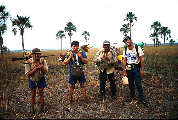
Fig.
1: Archaeologist Clark Erickson (far right) with local guides in Baures,
Bolivia.
In 1995, we were invited by the local governor to begin archaeological
investigations in Baures, a remote region of seasonally flooded savannas,
wetlands and forest islands in northeast Bolivia. He loaned us his Cessna and
pilot for an initial aerial survey of the region. As the plane circled the
landscape, we saw an amazing complex web of straight roads, canals, and moated
earthwork enclosures below. During the dry season of 1996, I surveyed the area
accompanied by a group of local hunters (Fig. 1).
One artificial feature, referred to as a zigzag earthwork, particularly
intrigued me. Low earthen walls zigzag across the savannas between forest islands
(Fig. 2). Because of their changing orientations, they did not make sense as
roads between settlements. As we mapped them with tape measure and compass, I
noted that there were small funnel like opening where the earthworks changed
direction. I immediately realized that these matched the description of fish
weirs that are reported in the ethnographic and historical literature on
Amazonian peoples. Fish weirs are fences made of wood, brush, basketry, or
stones with small openings that extend across bodies of water. Baskets or nets
are placed in the openings to trap migrating fish. While most fish weirs are
simple ephemeral structures crossing a river or shallow lake, those of Baures
are permanent earthen features covering more than 500 square kilometers. In
addition, small artificial ponds are associated with the fish weirs (Fig. 3).
Today these ponds are filled with fish as the floodwaters recede in the dry
season. I believe that in the past these were used to store live fish until
needed. Our studies show that the weirs were used before the arrival of
Europeans to the region.
The scale of the fish weir complex is larger than any previously
reported. The native peoples of Baures shaped the environment into a productive
landscape capable of providing sufficient protein to sustain large populations.
The people responsible for this impressive land management are long gone or
have forgotten the technology. Archaeology provides the only means of
documenting this important lost knowledge. As politicians, conservationists,
and aid agencies seek sustainable solutions to both develop and conserve the
Amazon, archaeologists can play a key role by providing time-tested models of
land use.
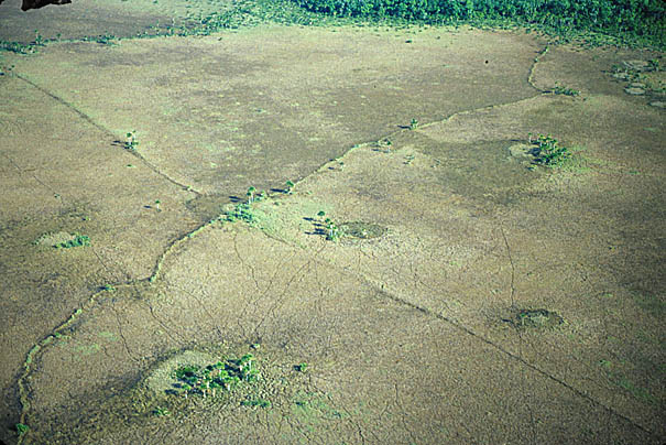
Fig.
2: Remains of fish weir (lower left to
upper right) and fish ponds
(circular
features surrounded by palms) from the air.
BIBLIOGRAPHY:
Erickson, Clark L.
2000. “An
Artificial Landscape-Scale Fishery in the Bolivian Amazon.” Nature.
408:190-193. [view
or download]
2000. “The Lake
Titicaca Basin: A Pre-Columbian Built Landscape.” IN Imperfect Balance: Landscape Transformations in the Precolumbian
Americas. Edited by David Lentz, Columbia University Press, New York, pp.
311-356. [view or
download]
For
more information about this research, visit the Web Site “An Artificial Landscape-Scale Fishery
in the Bolivian Amazon.”
Return to Fish Weirs of the Bolivian
Amazon home
Return to Applied
Archaeology in the Bolivian Amazon
Return to Clark L. Erickson homepage