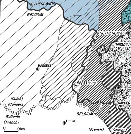
The transition from German to Dutch in the Limburg area
Illustration of the problem of two Ausbau languages that
don't show much Abstand in this area.
- The dialect spoken around Limburg
has been investigated by Goossens, who
produced these dialect maps of the Limburg
area which, in addition to being a province in Belgium, is a
larger transitional dialect area encompassing part of Germany, a
German-speaking area within Belgium, a `panhandle' of Dutch territory
extending a tongue of land into this area, around the city of Maastricht,
and then on into Flemish-speaking Belgian territory, and Dutch territory.
- The map illustrates the spread of the sound [
 ] as contrasted
with plain [s], across this territory, moving from east (Germany) to west.
The position of the isoglosses have no relationship whatsoever with the
political boundaries in the area, spilling across both political borders
and `language' borders. The key to the map shows how the widest
distribution of [ ] is found in
German (labelled "6" in the key), where it occurs in all environments; as
it moves west, it loses steam and is found in fewer and fewer
environments, until it is found only in loan words (environment 1
in the key) in Standard Dutch and Flemish.
] as contrasted
with plain [s], across this territory, moving from east (Germany) to west.
The position of the isoglosses have no relationship whatsoever with the
political boundaries in the area, spilling across both political borders
and `language' borders. The key to the map shows how the widest
distribution of [ ] is found in
German (labelled "6" in the key), where it occurs in all environments; as
it moves west, it loses steam and is found in fewer and fewer
environments, until it is found only in loan words (environment 1
in the key) in Standard Dutch and Flemish.
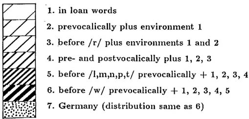
- If you know standard German, you know that almost everywhere English
has [s] before a consonant, German has
[
], written
sch (or
before stops, spelled s but pronounced [], as in
stinken
for English `stink') schmusen for English `smooch',
schlachten `slaughter', etc.
English is thus part of the territory west of the Dutch territory, not
reached by this sound change. The fact that [] is spelled
s
before stops tells us that the orthography of standard German was fixed
before this part of the sound change had taken place; the other
parts of it must have taken place before the orthography was fixed, so
they represent the change by spelling it sch- .
- Thus the transition from German to Dutch is gradual, but if you were
walking across this territory (note the scale on the map: you could walk
across the narrow portion of the Maastricht `panhandle' in a very short
time) and asked someone where you were linguistically, they'll
give you a political answer, i.e. the perception of where this occurs has
more to do with politics than with actual observable linguistic behavior.
A naive linguist walking across the territory from Aachen to Brussels
would have no idea that s/he had crossed a number of political borders,
and had left one `language' and entered the territory of another.
- To complicate matters even further, note that there are some
`German'speaking territories (and even Flemish territory) within French
`speaking' Wallonia. The German territory is recognized as such, the
German language is allowed (the area is called Eupen-Malmédy) and
everyone
is happy. (yeah, right!) I once drove through this area and had
no idea it was German-speaking; the road signs were all in French!
- In an attempt to show both political borders and isoglossal borders,
I colorized the map:

Green represents Germany, pink represents French-Belgium (Wallonie),
yellow is Netherlands, blue is Flemish Belgium.
- The Goossens material, including the original map, comes from
Jan Goossens, Strukturelle Sprachgeographie: Eine Einführung in
Methodik und Ergebnisse, Heidelberg, Carl Winter
Universitätsverlag,
1969. These versions of the map were produced by Roland Breton, and
reproduced in Geolinguistics: Language Dynamics and Ethnolinguistic
Geography, Ottawa: University of Ottawa Press, 1991.
- Note: since 1997 "Limburgish" is recognised as
a regional language in the Netherlands (not in Belgium), and therefor
gets protection by the European
Charter for Regional or Minority Languages
haroldfs@ccat.sas.upenn.edu