|
|
Charting the Indian Ocean from Zanzibar to Sumatra
II. THE APPROACH TO THE INDIAN OCEAN FROM THE WEST
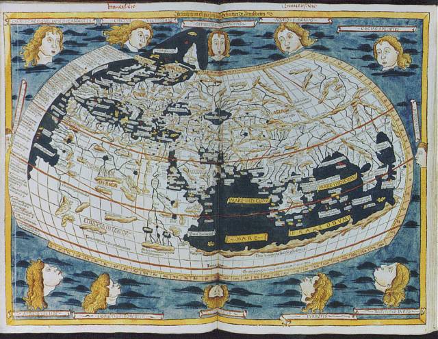
A. Claudius Ptolemy (c.87-150 C.E.)Ptolemy was a Greek mathematician and geographer who lived in Alexandria, Egypt, in the 2nd century C.E. and compiled a world gazetteer, called Geographia, of over 8,000 place-names from Scotland to Malaya. Whether he drew maps to illustrate his written work is a subject of dispute among scholars because none was extant in the 15th century when it resurfaced after a thousand years of obscurity. Many European Renaissance cartographers included renditions of his Geographia when they printed their own maps.
In pure speculation, Ptolemy depicted the Indian Ocean as an enclosed sea. He introduced the terms “longitude” and “latitude,” and suggested his own coordinates for geographical locations. His work had two main faults, however: it greatly overestimated the distance from Europe to Asia and, where Ptolemy had no knowledge of the geography, he filled in the blanks with theoretical conceptions.
Copies of Geographia passed throughout the Mediterranean world, first to the Byzantine empire headquartered in Constantinople. It was translated into Arabic in the 8th century, into Greek later, and into Italian Latin in the 15th century.

Home|
The West
| Charting
| Commerce
| Madras
| Picturesque
| The
Horn
The web sites include links to sites outside the control of the authors. The authors are not responsible for information on these or other such linked sites. Please respect the copyright notices attached to the Web Sites you view.
© 2002 Penelope Campbell. All rights reserved.