|
|
Charting the Indian Ocean from Zanzibar to Sumatra
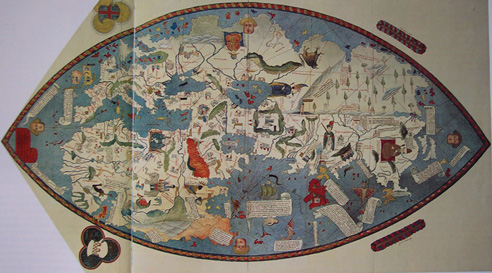
B. Catalan World Map (1375)It was drawn on parchment and brightly colored by a Mallorcan artist, Abraham Cresques, for Charles V of France. It is considered one of the great monuments of medieval cartography because the world it shows comprises only Europe, North Africa, and Asia. It also retains many of the legends and fables of medieval geography. However, the author was innovative in orienting the map to the north and in showing compass-lines. His obvious reference to early Mediterranean sea charts produced an accurate depiction of the coasts. The eastern part of the map, based on Ptolemy, is vague with regard to Asia, but it does have additions from Marco Polo, whose observations heretofore had been largely ignored by cartographers. This was the first map to portray the Indian sub-continent in its peninsular form.
C. Genoese World Map of 1457
The author and circumstances of its publication are unknown, although some scholars attribute it to a leading 15th century Florentine cosmographer. The map incorporated the findings both of Marco Polo and of a more recent Venetian traveler, Niccolo de Conti, who returned in 1444 after twenty-five years of wandering in South Asia. Unlike most early maps, it is oriented toward the north and it has the proportions of the three continents and the Indian Ocean approximately correct. The Indian Ocean is depicted as open, reachable by navigating around Africa, and as having islands, including Ceylon and Sumatra.
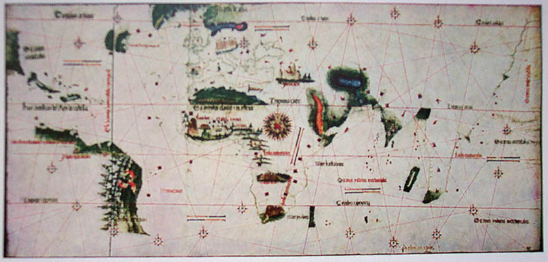
D. Cantino Chart (1502)
This, the first known planisphere, was drawn by Portuguese artists and smuggled out of Portugal under suspicious circumstances by an Italian diplomat, Alberto Cantino. Following soon after the voyages of Vasco da Gama and Cabral, it presents in recognizable form the New World, Africa, and India. The Far East is only a rough outline, understandable since, at the time of the map, the Portuguese had reached no farther east than the west coast of India. Nevertheless, the author apparently used miscellaneous facts from written Indian Ocean pilot guides and a little imagination to extend his map eastward beyond Cape Comorin. The Brazilian coast dominates the western section and the coast of Africa is mapped with startling accuracy. The map shows a good deal of Arab influence in the use of Arab place names, the Pole Star altitudes, and Arab longitudinal distances. It had an enormous impact throughout Europe by spreading new ideas about world geography.
Home| The West | Charting | Commerce | Madras | Picturesque | The Horn
The web sites include links to sites outside the control of the authors. The authors are not responsible for information on these or other such linked sites. Please respect the copyright notices attached to the Web Sites you view.
© 2002 Penelope Campbell. All rights reserved.