|
|
Charting the Indian Ocean from Zanzibar to Sumatra
III. ISLAMIC CARTOGRAPHY AND THE INDIAN OCEANAfter Christians destroyed the classical works of Ptolemy and others in Alexandria in the 4th century, they were preserved in the libraries of such Middle Eastern cities as Antioch and Damascus. Here, later, they assumed a special importance to Arab scholars because, with the spread of Islam east and west after the Prophets death in 632 C.E., accurate geographical knowledge became a prerequisite for adhering to the teachings of the Koran. If Muslims were to observe the Qibla (praying five times a day facing Mecca) and if they were to perform the Haj (the pilgrimage to Mecca once in their lives), they had to have guidance on the direction of Mecca and the route. First, in the 8th century, Arab scholars translated Ptolemys Geographia into Arabic, probably from Syrian texts. They then began making maps of their own in the early 9th century and were possibly aided by access to Byzantine world maps in the Ptolemaic tradition.
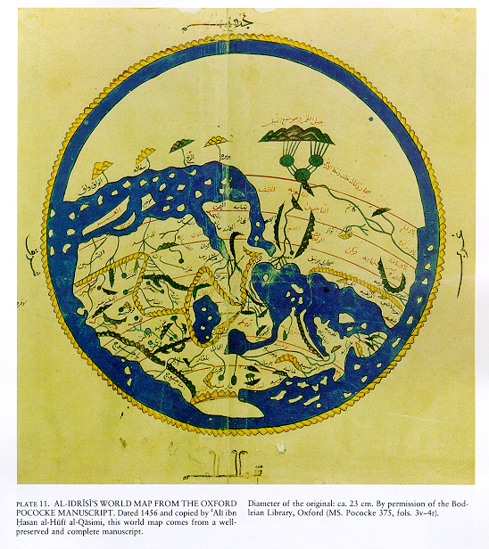
The most famous cartographic work was done by al-Sharif al-Idrisi (1100-1166 C.E.), who was born in Ceuta, Morocco, and later studied at the University of Cordova, which held a large repository of information on various countries. He traveled in France, England, Central Asia, and Constantinople before settling in Palermo about 1138 as a geographer to the Norman court of Roger of Sicily. Al-Idrisis world map blended many of the theories of Ptolemy and of other Greeks and Romans, as well as those of earlier Arab cartographers. His map, issued in 1154 C.E., was oriented to the south and divided the world into seven climates, which the early Greeks had proposed. Arabia is central, but Western Europe, Asia, and North Africa are shown in considerable detail. He kept the Indian Ocean land-locked in the south, but open in the east, with an outer encircling ocean.
Al-Idrisis map is an interesting contrast to both contemporaneous European maps and to those produced centuries later in the absence of cities, castles, animals, legends, saints, or monsters. It is strictly secular and free of imagery, allegorical or religious.
Home|
The
West | Charting
| Commerce
| Madras
| Picturesque
| The
Horn
The web sites include links to sites outside the control of the authors. The authors are not responsible for information on these or other such linked sites. Please respect the copyright notices attached to the Web Sites you view.
© 2002 Penelope Campbell. All rights reserved.